
On Providence, Enclosure, and the Tides
ASEH 2025 Presentation
Providence, Rhode Island is on the northwestern coast of Narragansett Bay, which is part of the ancestral homelands of the Narragansett people.[1]
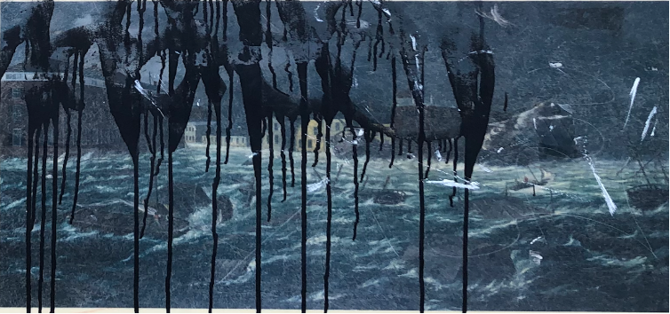
In 1973, news reporter Carol McCabe wrote an article for the back pages of the Providence Sunday Journal about a witches’ coven. Members of the group included a “nervous businessman” and an “affable truck driver,” among others who preferred to remain anonymous. Coven leader Ronnie Davey, on the other hand, was eager to talk. She shared a recurring vision with McCabe in which downtown Providence, a former tidal marsh and riverbed, succumbed to a terrible flood:
“In my vision, it has been raining all day. I am standing in the Outlet [department store] parking garage and I see a huge wave coming towards the Fox Point Hurricane Barrier. As it approaches, the wave is as high as the Industrial National Bank Building. The wave crests at the dam, then rolls into the city. I find myself standing in water to my hips.”[2]
For Davey, the scene portended a near-future deluge. And yet, in her quoted words to the reporter, Davey seemed less-than-certain of its place in time. She tried to pin a date, but the very contents of the vision made it hard to say for sure:
“It is cold, which means it is a winter month, and it is just getting dark, which means it must be about five or six o’clock. The stores are open so it might be a Thursday night, I think. People are wearing clothes that look like the 1920s—long skirts and big fur jackets. All of these things make me think it might be this year, and another reason is that other people have begun picking it up in their dreams.”
To older residents of Providence, Davey’s vision might have sounded more like testimonial than prophecy. Downtown had flooded under tidal waves before. Hurricane Carol of 1954 delivered over 13 feet of water to the partly filled land of the Financial District, where the Great Salt River used to be. The Hurricane of 1938 was similarly monstrous (and by the way, it’s fun to note here that the word monstrous is a derivative of the Latin monere, which means “to remind, bring to (one’s) recollection, tell (of); admonish, advise, warn, instruct,” or “teach.”)[3]
In any event, the one thing that most sets Davey’s vision apart from these historic deluges is “the dam” where she sees the wave crest before rolling forward. Officially named the Fox Point Hurricane Barrier (FPHB), the dam had been built in 1966 by the Army Corps of Engineers in the wake of Hurricane Carol expressly to preclude storm surges from ever wreaking havoc on the district again. Time will tell. But so far, the Barrier has been successful, which is to say that Davey’s vision hasn’t yet come to pass.
Today, if you stand on the Providence River Pedestrian Bridge and look south towards the horizon, you can see the straight-and-narrow channel of the river’s downtown segment open out to Narragansett Bay, which leads directly to the ocean twenty-five miles farther south. For me, sometimes the nearness of those deeper waters has a heart-sinking pull. I can feel the latent force that is contained by the Bay, and as it did for Ronnie Davey circa 1973, a mind’s eye image of a great wave comes to me unbidden. It’s a dizzying contrast between the intimation of that force, which is restless, and the seeming fixity of the bridge, the parks, the buildings; even the river itself, with its gentle currents and clear bounds.
Downtown Providence is prone to flooding because it was built on landfill. The growth of the district entailed the desiccation of marshes, the leveling of hills, and the canalization of once-great water bodies. And though reclamation has been a fait accompli since the 1890s, land and water are still kept strictly separate–even through recent years, as planning and development have reoriented to the rivers in the form of public parks and new construction. I recall this process not because it is exceptional—cities were built and later reinvented in similar ways across the Northeastern U.S.–but because it is too-little-acknowledged, and when acknowledged, too-narrowly framed, such that the cultural and ecological richness of what was destroyed is barely registered.[4]
The downtown riverfront is arrayed with plaques, most dating to 1996, that recount the history of reclamation, but in the narrative they proffer, the water bodies are cast more as formal elements of a built landscape than as socio-ecological assemblages. Reclamation is not celebrated per se, but it is presented as an originary event; the staggered action by which history begins and lurches forward. The life-supporting capacities of the estuary are not considered, and thousands of years of human connections are eclipsed.
The built environment is the shape of this forgetting. Which is to say that for the past two centuries, downtown development has been predicated upon a sort of temporal purification, whereby land is wrested from, and secured against, the tides.[5] The tides are placed outside of history. And though a lot has changed since the 1970s, what’s changed least of all is the normative socio-ecological disconnection of land from water, which is to say the closing off of downtown, where the marshes, hills and rivers used to be, from the unruly worlding of tidal flows. And yet, as I have often felt while standing at the district’s eastern edge where the inner harbor meets the Bay, the achievement of the land’s enclosure against the rest of nature is temporary and fragile.[6]
[1] An Anglicized rendering of the indigenous word Nahahiganseck, Narragansett means “the people of the small points” (i.e., the Bay’s fingered coastline). Lorèn Spears, Executive Director of the Tomaquag Museum, “Indigenous People in the Narrow (Pettaquamscutt) River Watershed” (Narrow (Pettaquamscutt) River Watershed, July 12, 2019), accessed April 24, 2024, https://narrowriver.org/indigenous-people/.
[2] McCabe, Carol, “Nothing Says Lovin’ like Meeting with the Coven,” Providence Sunday Journal (RI), March 11, 1973, E1.
[3] https://www.hurricanescience.org/history/storms/1950s/carol/; https://www.etymonline.com/word/monster
[4] The absence of the indigenous past from the downtown plaques is particularly glaring. By my count, in 2021, there were forty-two interpretive plaques and historic images around the downtown segment of the Providence River and its tributaries, the Moshassuck and Woonasquatucket. Of those, only one mentions indigenous people, but the mention largely functions to re-establish the myth of indigenous peoples’ replacement by settlers. Titled “Roger Williams Landing 1636,” the plaque in question is very much about Williams, but it invokes two local sachems as witnesses to Williams’ integrity, namely, Wampanoag sachem Metacom, known to the English as “King Philip,” and Narragansett sachem Canonicus. The plaque reads:
[Williams] was respected by the Indians as was no other English man. Even King Philip listened to his counsel. When Canonicus, Sachem of Narragansett, lay dying, he asked Williams to close his eyes for him. Williams wrote, ‘When the hearts of my countrymen and friends failed me, His infinite wisdom and merits stirred up the barbarous heart of Canonicus to love me as his son to his last gasp.’”
The occasion of Canonicus’s fleeting appearance is the moment of his “last gasp.” And in this way, in this narrative universe, he effectively stands in for the Narragansett and other Indigenous people of the region who are almost completely absented from the story of the colony’s subsequent growth as told through the plaques. The “barbarous” Canonicus only appears to disappear, it would seem, so that the destined colonial order can take hold. For a study of similar “replacement narratives” in popular histories of New England, see Jean M. O’Brien, Firsting and Lasting: Writing Indians out of Existence in New England, Indigenous Americas. (Minneapolis: University of Minnesota Press, 2010). Installed in 1996, the plaques were authored by William Warner and Albert Kylberg. See Dujardin, Richard C., “River Walk Retraces City’s Steps *Twenty-One Fiberglass Panels at Strategic Locations along the River Walk Are Designed to Give Strollers a Clearer Understanding of Providence as It Was, and Is Now,” Providence Journal, October 3, 1996; Phipps, Peter, “Along Providence’s Rivers, City’s History Ebbs and Flows,” Providence Journal, April 19, 1998.
[5] I take the notion of purification as a core logic of modernity from Bruno Latour, We Have Never Been Modern (Cambridge, Mass.: Harvard University Press, 1993).
[6] Nikhil Anand, “Anthroposea: Planning Future Ecologies in Mumbai’s Wetscapes,” Environment and Planning. D, Society & Space 41, no. 4 (2023): 683–706.
